
What is Household Resource Mapping?
Household resource mapping is a participatory process in which community members, often with the help of facilitators or extension workers, create a detailed visual representation of their land, assets, and natural resources. This approach identifies how resources such as farmland, water sources, grazing areas, financial resources, and gardens are distributed and used within each household. It serves as a critical entry point for tailoring climate services to individual households' specific needs, vulnerabilities, and capacities.
Why Household Mapping Matters for Climate Services
Climate services aim to provide relevant, actionable climate information that supports decision-making at all levels. However, it should be noted that the household contexts differ from one house to another depending on their wealth, gender roles, assets they own, and livelihood strategies. It is for the same reasons that different households respond differently to the same weather shocks in the same village. Household resource mapping bridges this gap by:
- Understanding how households allocate land and labor to crops, livestock, and other activities helps tailor climate forecasts and advisories to real-world conditions
- Mapping exposes which households may be more vulnerable to climate shocks due to limited resources or labor constraints, enabling targeted support.
- Enabling Co-production of Climate Information by encouraging household participation in interpreting climate data, hence increasing trust and adoption of climate services.
- Revealing gendered divisions of labor and resource control, guiding the design of inclusive climate services that empower women and marginalized groups.
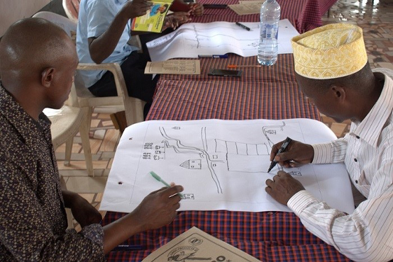
Practical Example: Household Mapping in Lushoto, Tanzania
In Dule village, located in the Lushoto District of Tanzania, Mr. Ramadhani was facilitated to draw his household resource map and locate the land for field crops, a plot for beekeeping, and spaces for zero-grazed livestock and vegetable gardens.
Facilitated by an extension worker, Mr. Ramadhani was equipped to develop a seasonal calendar, which enabled him to explore the timing of main activities, specifically for beans, maize, and dairy cows. The calendar helped Mr. Ramadhani determine how the rainy season would influence livelihood activities over a period of three months. The calendar information also calls for the household division of labor, in which adults and youths (both males and females) were assigned specific tasks before and during the production period.


Integration with National and Global Climate Services Frameworks
Household resource mapping aligns with the principles outlined in the Tanzania National Climate Services Framework (NCSF) and the Global Framework for Climate Services (GFCS). Both frameworks emphasize user-centered design to ensure relevance and usability, multi-scale data integration to enhance the precision and impact of climate advisories, and continuous feedback and engagement with households to allow climate services improvements based on user feedback and changing conditions.
Way forward
Integrate household resource mapping into district-level climate service programs and agricultural extension planning as a standard practice. Simultaneously, train and equip extension workers with participatory tools and skills to facilitate it effectively at the community level. This enhances local relevance, long-term adoption, fosters community ownership, and improves adaptation outcomes.
To enhance widely adoption of the process, extension workers can proactively identify and support role models by systematically assessing their production potential ahead of the season. Documenting and sharing their experiences inspires wider community participation and accelerates behavior change by demonstrating its value in aligning livelihood planning with climate forecasts.
Co-create user-friendly planning tools such as seasonal calendars, planting guides, and climate risk checklists with households, using data from household resource mapping and local forecasts. Ensure these tools are translated into local languages and accessible to all members of the household. This enhances decision-making and resilience at the household level.
